The Far North & Arctic Alaska Float Trips
Its Boundaries
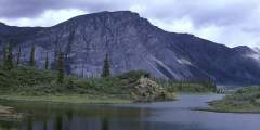
Lying above the Arctic Circle, and flowing north from the Brooks Range Mountains, these rivers lie in the National Petroleum Reserve, the Arctic Slope and the Arctic National Wildlife Refuge.
What It’s Like
The Far North rivers all lie in the less forested permafrost zones, and have a very short summer season; winter weather begins as early as mid-September.
During spring, hundreds of thousands of caribou migrate to this area, just as the rivers and their surrounding plains fill with migratory and nesting birdlife—such as peregrine falcons, rough-legged hawks and golden eagles. This is also the land of Dall's sheep, bears, wolverines, and even Musk Ox, whose populations were decimated in the past, but are rebounding now.
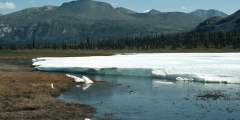
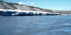
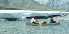
Most of the rivers, however, are locked in ice until mid-June. Throughout the summer, the rivers show daily fluctuations, as the snowfields and Aufeis melt during the day and flow into the valleys at night.
The rivers tend to have fairly easy runs, though, thanks to their old age and the flattening effects of geologic processes. They’re so old, in fact, that it’s not uncommon to find a Mammoth tusk sticking out of an eroding riverbank. This area also offers countless options for long hikes, with huge vistas as the midnight sun hovers overhead.
Show Map
Float Trips
The Far North Alaska Float Trips
The Sheenjek River flows 290 miles from Alaska’s Brooks Range to Fort Yukon, earning a National Wild and Scenic River designation. It offers canoe and kayak trips through vast wilderness, with routes from 120 to 268 miles. Most of its length lies within wildlife refuges and serves as winter range for the Porcupine Caribou Herd. Olaus and Mardy Murie chronicled its history in Two In The Far North.
The Porcupine River flows 500 miles from Canada to Alaska, joining the Yukon River near Fort Yukon. A Class I wilderness trip, it passes through boreal forests and is home to the Porcupine Caribou herd. Used for centuries by Gwich’in Athapaskan traders, it features smooth-walled canyons and scenic flats. Popular routes start in Old Crow, with trips ranging from 10 to 14 days, depending on the put-in location.
The Noatak River, a Wild and Scenic River, flows 400 miles through the Brooks Range and tundra, offering stunning scenery, fishing, and wildlife. It begins in Gates of the Arctic National Park, meandering through valleys, canyons, and rolling hills before reaching Kotzebue Sound. Primarily a Class I‑II river, it’s ideal for canoes and kayaks. Trips range from a week to 28 days, with mosquitoes being a seasonal challenge.
Overview The Marsh Fork is a tributary of the Canning River, an arctic river that forms the western boundary of the Arctic National Wildlife Refuge and flows through the dramatic Phillip Smith Mountains and past the Franklin Mountains. The trip we describe is a 35-mile section of the Marsh Fork and a 5‑mile stretch of the Canning River to the first takeout option that is a gravel strip at Plunge Creek. The Marsh Fork requires some Class… ...more
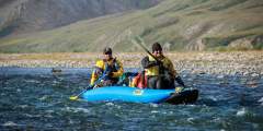
The Kongakut River in Alaska’s Arctic Refuge offers rafting, hiking, and wildlife viewing in a remote tundra landscape. Flowing from the Brooks Range to the Beaufort Sea, it features Class II – III rapids, caribou, moose, and Arctic char. August brings autumn colors, while summer’s midnight sun extends adventures in this fly-in-only Arctic wilderness.
The Ivishak River, 95 miles long, originates in glacial lakes, flowing north through Alaska’s Arctic National Wildlife Refuge. It transitions from rocky riffles to a wide, braided floodplain, fed by glaciers and springs. Rich birdlife, over 100 species, thrives here. The upper section is a designated Wild and Scenic River. It joins the Sagavanirktok River near Prudhoe Bay. A 90-mile Class I/II float, taking 5 – 10 days, is possible. Extended trips ...more
The Hula Hula River is a classic Arctic adventure, featuring 80+ miles of whitewater, mountain scenery, and vast coastal plains. It flows through the 10 02 Land, home to the Porcupine Caribou Herd, at the heart of oil drilling debates. Paddlers may see caribou, polar bears, and eider ducks while navigating Class III+ rapids. Solid planning is essential for this 10-day journey to the Beaufort Sea.
The Firth River, Canada’s oldest, flows through Yukon’s Ivvavik National Park, home to caribou migrations and rich history. This remote, 150-mile river features rugged landscapes, Class III-IV rapids, and excellent Arctic Char fishing. Flowing through four unique regions, it offers an unparalleled wilderness rafting experience. Permits are required, and trips take 6 – 10 days in this pristine Arctic setting.
The Colville River flows from the DeLong Mountains through Arctic tundra, draining into the Arctic Ocean. Frozen for much of the year, it floods each spring. Its cut banks hold dinosaur fossils and support one of North America’s largest Peregrine Falcon populations. A 375-mile section, mostly Class I‑II, can be floated in up to 20 days, passing through one of the continent’s most remote regions.
The Canning River flows from the Phillip Smith Mountains, forming the Arctic Refuge’s western boundary. Ideal for small boats, it features a wide, glacier-carved valley with meandering channels. Though not a whitewater challenge, low water levels can make navigation tricky. A 14-foot raft or inflatable kayak works best. Expeditions Alaska offers 7 – 12 day guided trips through this remote Arctic wilderness.
Just north of Fairbanks, Alaska, flowing out of the low mountains and rolling hills west of Chena Dome and south of Mastodon Dome, is the Birch Creek National Wild and Scenic River, one of only a few rivers of this status that is accessible by road and requires no flying in or out to do the 126-mile section of Class I to III+ river. A swift, shallow stream, Birch Creek begins above its confluence with Twelvemile Creek and for the first 10… ...more

