Kennicott Glacier
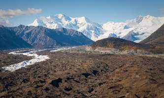
It’s a badland of ice—an expanse of rock, silt mounds, exposed fins, lateral moraines, strange landforms and patches of exposed ice. This glacier dominates all views west of the historic mill town site of Kennecott (basically located "across the street" from the Kennicott Glacier Lodge) in the heart of Wrangell-St. Elias National Park. Although Kennicott Glacier has been receding from its terminus for years, its immensity and ruggedness remains a magnificent sight, filling the four-mile-wide valley like a mighty river. The glacier stretches uphill to its source on 16,390-foot Mount Blackburn, Alaska’s fifth tallest peak and a spectacular sight on clear days.
Best Viewing Spots
Just about every place in Kennecott opens onto a view of Kennicott Glacier, owing to the town’s perch part way up the mountainside above the glacier. From McCarthy, walk, bike or take a shuttle about five miles up the road to the Kennecott town and visitor center, and then seek out any vantage with a view to the west. The rocky, gnarly-looking glacier will yawn at your feet! Another option involves hiking about 1.5 miles from McCarthy to the glacier’s toe—not far upstream from the footbridge over the Kennicott River. (Check for current directions at the McCarthy Museum.)
Getting There
Coordinates
Latitude: 61.60028Longitude: -143.07
The Kennicott Glacier lies near the end of the McCarthy Road, about 310 miles east of Anchorage in the heart of Wrangell-St. Elias National Park. Getting there requires a six-to-eight hour drive over the Glenn, Richardson and Edgerton highways, followed by a 60-mile trip up the McCarthy Road. To access McCarthy, visitors must park and then walk or ride bikes across the Kenneicott River over a pedestrian bridge. Most visitors take a shuttle bus another five miles to visit the mill town of Kennecott.


